El Niño Winter Snow Map: Where Could the Most Snow Fall in the U.S.?

A strong El Niño is expected to influence the 2026–2027 winter pattern across the United States. Forecast guidance points to a wetter and stormier southern tier, while norther...
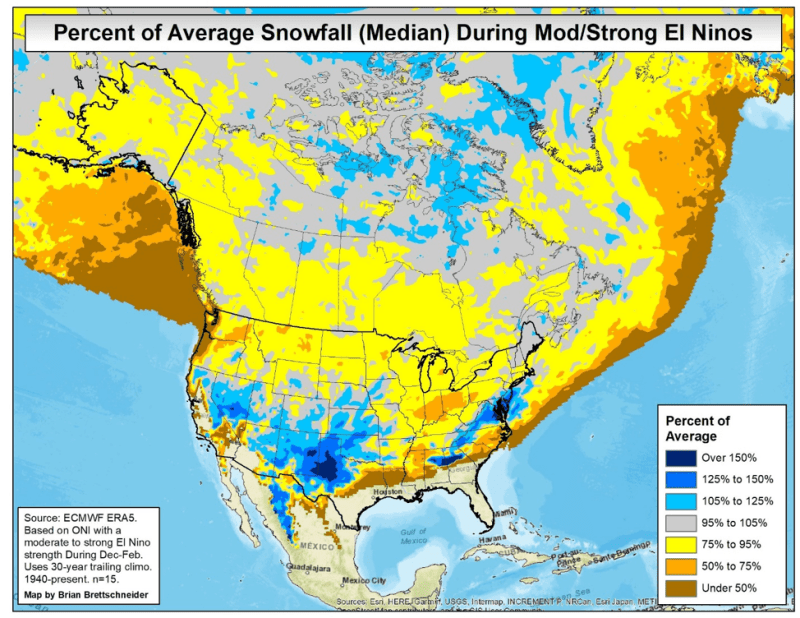
A strong El Niño is expected to influence the 2026–2027 winter pattern across the United States. Forecast guidance points to a wetter and stormier southern tier, while northern states may experience warmer and drier conditions.
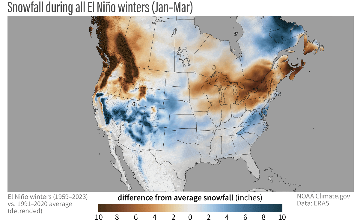
The latest winter outlooks suggest that the most favorable conditions for above-average snowfall may develop across parts of the Southwest, California, Utah, Arizona, New Mexico, and the southern Rocky Mountains.
However, a precipitation map is not automatically a snow map. Wetter-than-normal conditions can produce rain, sleet, freezing rain, or snow depending on temperatures and elevation. The areas most likely to receive significant snowfall are locations that combine an active storm track with sufficiently cold air.
Must Read
Southwest and Southern Rockies
The Southwest is one of the regions with the strongest potential for a snowier-than-average winter. California’s Central Sierra, parts of Utah, Arizona, New Mexico, and southern and eastern Colorado may benefit from a stronger southern storm track.
Repeated Pacific storm systems could bring additional moisture into the region. In higher elevations, that moisture may translate into improved snowpack and above-average snowfall, particularly during the early and late parts of the winter season.
States With Higher Snow Potential
- California: Especially the Sierra Nevada and Central Sierra.
- Utah: Mountain areas could see favorable snowfall conditions.
- Arizona: Higher elevations may receive more frequent snow events.
- New Mexico: Above-average snowfall is possible in mountain locations.
- Colorado: Southern and eastern areas may benefit, although the outlook is more variable across the state.
What About the Northeast?
Strong El Niño winters often bring warmer-than-average conditions to much of the northern United States, including parts of the Northeast. That can reduce the number of widespread snow events, especially when storms track too far north or temperatures remain above freezing.
Even so, the Northeast can still experience major snowstorms during an El Niño winter. Short-lived outbreaks of cold air may combine with coastal storms to produce heavy snow, particularly in northern New England and higher elevations. Seasonal outlooks cannot predict individual snowstorms months in advance.
In other words, a warmer seasonal average does not mean the Northeast will be snow-free. It means that the overall balance may tilt toward fewer snow opportunities or more frequent mixed precipitation.
Northern U.S. Could Be Warmer and Drier
A classic strong El Niño pattern typically shifts the jet stream southward across the United States. As a result, the Pacific Northwest, northern Rockies, northern Plains, Great Lakes, and parts of the Midwest may experience warmer or drier conditions than normal.
These conditions can limit snowfall, particularly at lower elevations. Some mountain areas may still receive snow, but the seasonal outlook generally shows lower odds of above-average snowfall across parts of the northern tier.
- Pacific Northwest: Temperatures may trend warmer, which could reduce snow accumulation at lower elevations.
- Northern Rockies: Snowfall may be below average in some locations.
- Northern Plains: A warmer and drier pattern could reduce winter storm frequency.
- Great Lakes and Midwest: Snowfall conditions may vary, with no guarantee of a consistently snowy season.
Why El Niño Changes the Snow Pattern
El Niño occurs when surface waters in the central and eastern tropical Pacific become warmer than normal. This changes the position and strength of the jet stream, the fast-moving band of air that guides many storms across North America.
During a strong El Niño, the jet stream often becomes more active across the southern United States. This can send more storms through California, the Southwest, the southern Plains, the Southeast, and parts of the East Coast.
At the same time, the northern tier may receive fewer major storm systems and experience warmer temperatures. The result is a pattern in which the South and Southwest may be wetter, while the northern United States is often warmer and less snowy.
Snowiest Periods May Come Early or Late
Some seasonal guidance suggests that snowfall could be concentrated during the early and late portions of winter, rather than being evenly distributed from December through February.
 La Niña effects merge with the Stratospheric Warming, as an El Niño is
For parts of the Southwest and southern Rockies, the strongest snowfall opportunities may occur from October through December and again during March and April. January and February could produce a weaker or less consistent snow signal in some areas.
This does not mean every location will follow the same pattern. Elevation, local geography, storm timing, and short-term temperature changes will determine whether a particular storm produces rain or snow.
Precipitation Does Not Equal Snow
One of the most important details when reading an El Niño winter map is the difference between above-average precipitation and above-average snowfall.
Much of the southern United States may be wetter than normal, but many communities across the Southeast typically experience rain rather than snow. A wetter winter in states such as Georgia, Alabama, or South Carolina does not automatically indicate a snowy season.
The best snow potential is generally found where three ingredients come together:
- Frequent storms moving along an active jet-stream track.
- Sufficient cold air near the surface.
- Elevation high enough to keep precipitation frozen.
How Reliable Is the Seasonal Snow Map?
Seasonal maps show broad climate tendencies, not exact day-by-day weather forecasts. They can indicate which regions have increased odds of wetter, drier, warmer, or colder conditions, but they cannot determine the exact number of snowstorms a city will receive.
Forecast confidence is generally higher for large-scale temperature and precipitation patterns than for local snowfall totals. A single shift in the jet stream can change whether a storm brings heavy snow to one area and rain to another.
Forecasters will continue updating the outlook as winter approaches. Short-range and medium-range forecasts will become much more useful for identifying specific snowstorms once those systems enter the forecast window.
El Niño Winter Snow Map: Key Takeaways
- California, Utah, Arizona, New Mexico, and parts of Colorado have some of the strongest potential for above-average mountain snowfall.
- The Central Sierra is one of the areas with a particularly favorable snow signal.
- The southern United States may be wetter and stormier, but much of that precipitation could fall as rain rather than snow.
- The Pacific Northwest, northern Rockies, northern Plains, Great Lakes, and parts of the Midwest may trend warmer or drier than average.
- The Northeast could still receive major snowstorms, even if its seasonal average trends warmer.
- Seasonal outlooks show broad tendencies and cannot predict individual snowstorms months in advance.
What This Means for the 2026–2027 Winter
The developing El Niño pattern favors a winter with an active southern storm track and increased moisture across parts of the West and South. For snow lovers, the best odds may be concentrated in the Southwest and southern Rocky Mountains, especially at higher elevations.
Northern states may see a less consistently snowy winter because of warmer temperatures and a weaker storm signal. Still, short-term weather patterns can produce significant snow anywhere conditions briefly turn cold enough.
The overall message from the map is not that the United States will experience one uniform winter. Instead, El Niño is likely to create a sharp regional divide: stormier and wetter conditions in the South and Southwest, with warmer and potentially less snowy conditions across much of the northern tier.
